News Department of Defense employee charged with unauthorized retention of classified documents Updated 4 hrs ago
News Rude Mechanicals presenting Shakespeare's 'As You Like It' at Kentuck Queen City Updated 5 hrs ago
News Department of Defense employee charged with unauthorized retention of classified documents Updated 4 hrs ago
News Rude Mechanicals presenting Shakespeare's 'As You Like It' at Kentuck Queen City Updated 5 hrs ago
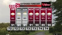
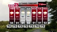
Weather Unsettled Weather Ahead... Thursday PM Forecast Update WVUA 23 Chief Meteorologist Richard Scott 3 hrs ago
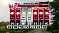
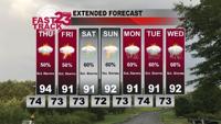
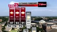
Weather Humid Weather... Scattered Storms Likely Ahead.... Wednesday PM Forecast Update WVUA 23 Chief Meteorologist Richard Scott Jun 25, 2025
We're always interested in hearing about news in our community. Let us know what's going on! Go to form
Summer silence: navigating loneliness on college campuses during the break News Summer silence: navigating loneliness on college campuses during the break During the summer, college campus activities and the student population decreases.
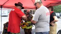
Local News Joe Eatmon is back as head coach for Shelton State men's basketball team Updated 8 mins ago
News Department of Defense employee charged with unauthorized retention of classified documents Updated 4 hrs ago
Alabama News AP Alabama sets August nitrogen execution for man convicted of 1992 shooting death Updated 4 hrs ago
News Alabama Attorney General: Stores flouting state's THC laws searched this week, more info coming Friday Jun 25, 2025